- Home
- News / events
- Avenue Road
- Biggin
- Buckingham Road
- Census 1841
- Chapels
- Charities & poor relief
- Church
- Church Street
- Directories / descriptions
- Enclosure
- Families / people
- Farms
- Fire insurance
- High Street
- Horn Street
- Maps
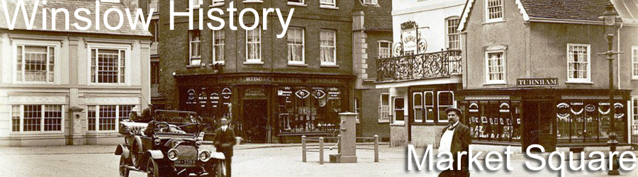
- Market Square
- Medieval & 16th century
- 19th-20th Centuries
- Oral history
- Parish Council
- Photographs
- Pubs
- Railway
- Redfield
- Schools
- 17th-18th Centuries
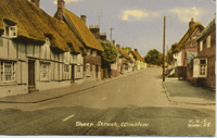
- Sheep Street
- Shipton
- Station Road
- Tanneries
- Tinkers End
- Turnpike
- Vicarage & Verney Roads
- Western Lane
- Wills
- Windmill
- Winslow Hall
- Workhouse / Hospital
- World War One
- Sitemap
- Links
- Search site
- About us / contact

Winslow History
Welcome to the Winslow History website. On this site you will find photographs, transcribed documents and short articles about the history of Winslow, Buckinghamshire, from the Anglo-Saxon period to the 20th century. Please scroll down for an introduction to the town's history, and use the menu on the left to navigate around the site. There is also a search engine at the foot of the page, and a full index of all the names on the website.
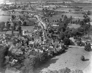
Picture of the month (October 2024): Bell Closes, 1930s
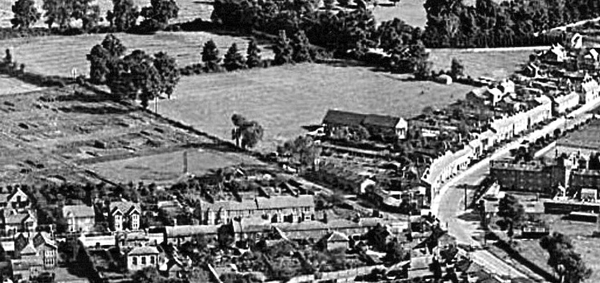
In the foreground of this aerial view you can see Station Road (left) and the Workhouse (right). The Baptist Tabernacle is in the centre, and behind it are the fields then officially called Bell Closes. After being ploughed up during WW2, they were acquired by the Parish Council in 1949 and laid out as the Recreation Ground for football and cricket. Read more.
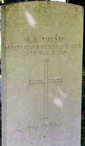
People from Winslow's past #141: Archibald Beresford Turner (1890-1919)
 A.B. Turner was an Australian carpenter who enlisted in December 1914, and was posted to Egypt and Palestine in 1915. He spent much time in hospital, and was sent to England in July 1916 "with disability caused from exposure while on active service". He then worked at the Australian Auxiliary Hospital at Harefield, Middlesex, which must have been where he met Louisa Leah Walker from Winslow. They married and were living in Harefield in December 1916.
Because of his ill health, A.B. Turner was sent back to Australia in March 1917 and discharged from the Australian Imperial Force. He then returned to England in early 1918 as a volunteer munitions worker, part of an attempt to make up for the wartime shortage of labour. He was taken ill with pneumonia and died in Bedford Military Hospital on 14 March 1919. His wife and her family arranged for him to be buried at Winslow, and his funeral was held on 19 March. His grave was marked with a Commonwealth War Graves headstone which is still in place (see photo). With thanks to Simon Cains for uncovering this story. Read more.
Winslow - an historical introduction
Winslow is an ancient royal manor, situated mid-way between Aylesbury and Buckingham. It was too near to either of these towns to have become a major commercial centre, but it was large enough to attract the agricultural surplus of the neighbouring villages. In 792, King Offa of Mercia gave Winslow, along with the villages of Granborough and Little Horwood, as an endowment for his new abbey at St Albans. An Anglo-Saxon charter, giving the original boundaries of the manor of Winslow, was discovered in the Royal Library in Brussels. The hamlet of Shipton was also part of the manor, with its own field system.
 The principal road through Winslow ran east to west, along Sheep Street and Horn Street, whose names evoke the smell of livestock sales. The Abbot of St Albans secured a market charter for Winslow in 1235 and carved out a market place from Horn Street and the Churchyard. At the same time, a new High Street was laid out, running north from the Market Square towards Buckingham. Here the shops were built on rectangular plots running back to a rear access road, later to be known as Greyhound Lane. The Abbot of St Albans built a tithe barn in Horn Street, but the present building dates from about 1700, and tithes were no longer collected after 1767. The Abbot also had a grange at Biggin, by the stream which divides Winslow and Granborough. This was where St Albans representatives stayed when they visited Winslow, and it was a substantial farmhouse in the 16th century, but little now remains except some earthworks. When the abbey was dissolved in 1539, the manor of Winslow passed to the Crown, and was eventually sold to Sir John Fortescue of Salden.
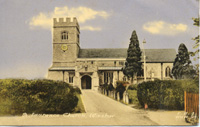 Winslow's oldest surviving building is St Laurence Church, parts of which date from the 13th century. The church was much altered by Victorian restoration, but some medieval features survive, including wall-paintings. Church Street provides access to the church from Horn Street and remains one of the most picturesque parts of Winslow.
Because Winslow belonged to a major abbey, it is very well documented. Detailed court books survive from the 1320s and include the names of those who died in the Black Death in 1348-9. Wills are another important source of information; there are over 200 from before 1600. From the same court books, it is clear that Winslow, and the separate hamlet of Shipton, were cultivated according to the 'open-field' system, where each farmer had a number of strips dispersed in three common arable fields. The enclosure of the open fields of Shipton in 1745 and Winslow in 1767 meant that all the land which the farmers had cultivated in common was reallocated, and quick-set hedges were laid around the new allotments. The enclosure also led to the diversion of several old roads. Verney Road replaced Western Lane as the main road to Addington and the road from Swanbourne to Buckingham, which had bypassed the town, was blocked in order to divert traffic through the Market Square. Furze Lane was created in order to give access to several small allotments of land to the west of the town. Farmhouses were built outside the town for the first time. Most of the arable land was turned into pasture, and the windmill ceased to function. The old farming system has left its mark in the ridge and furrow which can be seen all around the parish.
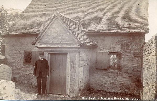 Winslow has a strong nonconformist tradition going back to the 17th century. The Baptist chapel now known as Keach's Meeting House was built in 1695, and is one of the oldest such buildings in Bucks, named after the Baptist preacher Benjamin Keach who was persecuted in the 1660s. A Congregational Church (now a private house) and Baptist Tabernacle were built in the 19th century, and the Salvation Army flourished briefly. The first endowed school was the Rogers Free School, set up by a will of 1722.
The old coach road from Aylesbury, which followed a Roman road from Quarrendon to Granborough and then headed for Buckingham via East Claydon, was diverted through Whitchurch and Winslow by the turnpike before 1745. This gave a boost to trade in the town, where the Banbury coach stopped at the Bell Inn (the foremost of the numerous pubs) or the Three Pigeons. Winslow’s cattle market flourished, and it was the home of a number of wealthy professional men serving the gentry of the surrounding villages. During the 18th century, there were two or three doctors, several attorneys and more than one surveyor, all of them occupying large houses near the Market Square, as shown in a directory of 1795. There are also extensive fire insurance records from this period.
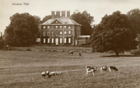 Winslow was the birthplace of William Lowndes (1652-1724), Secretary of the Treasury from 1695. His story is a piece of remarkable social mobility: as a son of an indebted farming and innkeeping family, he was sent off to London, where his work as a civil servant and four marriages provided him with a fortune which enabled him to buy the lordship of the manor and much of the land. Before 1700, Lowndes bought several farmhouses in Sheep Street and demolished them all to provide a site for a new country house. Winslow Hall was designed for Lowndes with help from Sir Christopher Wren. It was built to the highest standards by craftsmen used to building fine houses and public buildings in London. It changed the appearance and psychology of the town, which had never before had a “great house” or a resident “squire”. The Lowndes family (who moved to Whaddon Hall and added the name Selby) sold the Hall and estate (over half the parish) in 1897 but remained lords of the manor until the 1920s. Redfield, a Victorian villa, was also built for the Selby Lowndes family but was later sold to the Lambtons.
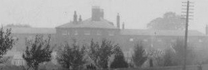 In 1834, the Poor Law Amendment Act brought about the sale of village poorhouses and their replacement by Union Workhouses in the larger towns. Winslow became the centre of a Union and a grim new Workhouse serving the town and neighbouring villages was built on Buckingham Road, designed by Sir George Gilbert Scott. A Board of Guardians was elected to run the Workhouse and the Rural Sanitary Authority was formed in 1872 as a sub-committee. The Sanitary Authority was replaced in 1894 by a Rural District Council, whose main legacy was the building of solid new houses to rent at Western Lane, Tinkers End, Demoram Close, Burleys Road, Missenden Road and Verney Road. These houses date from the 1920s to the 1950s when successive governments gave subsidies to local authorities to provide for general housing need and those displaced by slum clearance. Over 50 men from Winslow were killed in the First World War, and most of them came from families who had lived in low-quality housing, hence the "homes fit for heroes" slogan. The Parish Council was formed in 1895 and spent decades trying to avoid expense for the ratepayers; the first election was hotly contested but its limited powers soon became clear.
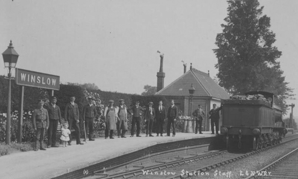 The northern part of Winslow developed in the Victorian period with the building of the Workhouse in 1838 and the laying out of Station Road to the railway station in 1850. The railway brought no industry to the town (although small-scale industrial activities such as tanning continued), but it did provide a route to London for local dairy products. The railway also made Winslow accessible to the London sporting fraternity, several of whom kept 'hunting boxes' in the town. Winslow estate agents always described the larger houses as close to the railway station and convenient for the meets of the Whaddon Chase, Bicester and Duke of Grafton's Foxhounds. Many photographs of Winslow from the late 19th and early 20th centuries have survived (a lot of them by Winslow's own photographer J.H. Turnham).
The town's population rose from 1,100 at the beginning of the 19th century to 1,890 in 1861 (see the full transcription of the 1841 census), but then declined to 1,500 by the Second World War. An airfield was built at nearby Little Horwood during the war and 13 residents lost their lives in 1943 when a Wellington bomber crashed on the High Street. The railway station was closed to passengers in 1968 and the line was reduced to a single track in 1985 but is expected to reopen in 2024.
 After the Second World War, the growth of private car ownership made small towns like Winslow attractive to commuters. The Elmfields Estate on the north side of the Aylesbury road was developed in the 1960s by the Metropolitan Railway Country Estates Company. The 1967 Winslow Plan set a population target of 5,000 and led to the development of the Magpie Farm Estate to the north-east of the town. The houses and a new primary school were built beyond the line of a bypass, originally proposed by the County Council in 1935, but abandoned in the 1990s. Despite proposals to re-open the railway line to Milton Keynes and Oxford, the former railway station was developed for housing, also in the 1990s. A site for a new station has been allocated to the west of the Buckingham Road, where the land was designated as public open space under the 1967 plan. More housing has now been built on former pasture west of the town and south of the railway.
The full text of Arthur Clear: A Thousand Years of Winslow Life (1888) can be read on this website. We have a full list of Winslow road names and their origins.
You can search for people on this website by using the index of names. If you are looking for someone specific, you are recommended to use the search engine below as well.